- GPS Tracking Survey
- Guide to Botanic Garden Creation
- Google Correlate Botanic Garden Visitor Patterns
- Space Use Analysis
- Natural Heritage Visitor Centre Report
- Narrative Landscapes
- Natural Visitor Centre Survey
- QR Codes in Visitor Attractions
- About us in Chinese
- Botanic Garden Infographic
- Gloucester City Botanic Garden
- Plantnetto
- Botanic Garden Competition (II)
- Barefoot Paths
- Making an Entrance
- Botanic Garden Competition
- Architect of the Year Awards
At FRLA, we have always believed that, for us to be able to be able to create successful designs, it is necessary for us to fully understand how people use spaces and places. As part of our continued learning, we have recently been developing our own methods for tracking and analysing visitor use. Using combinations of GPS tracking, video, visitor surveys and GIS analysis, we can collect detailed data on how people move within a landscape and analyse it to provide us and our clients with invaluable insights into their visitors’ behaviour.
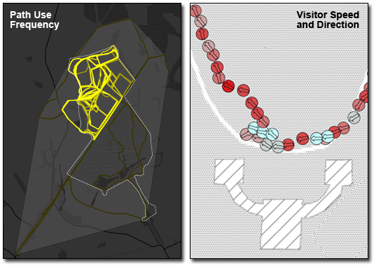
The images below are two examples of the results that can be produced. The image on the left shows the frequency of path use by walkers entering a site from one location. Note how this exercise shows that the road running diagonally across the site acts as a psychological barrier to many of the walkers. The image on the right shows more detailed information about how one visitor interacted with a folly in a landscape garden. The colour symbols show their direction and speed with red indicating fast movement and blue slow movement. Note how the visitor briefly stops twice in front of the building before moving on.